La Mauricie National Park: Breathtaking Beauty Near Shawinigan, Quebec
La Mauricie National Park is a hidden gem in the world of Canada’s national park system. It may not have as recognizable a name as some other parks in this nation, but La Mauricie is utterly gorgeous, and if you make the trip, you will not be disappointed.
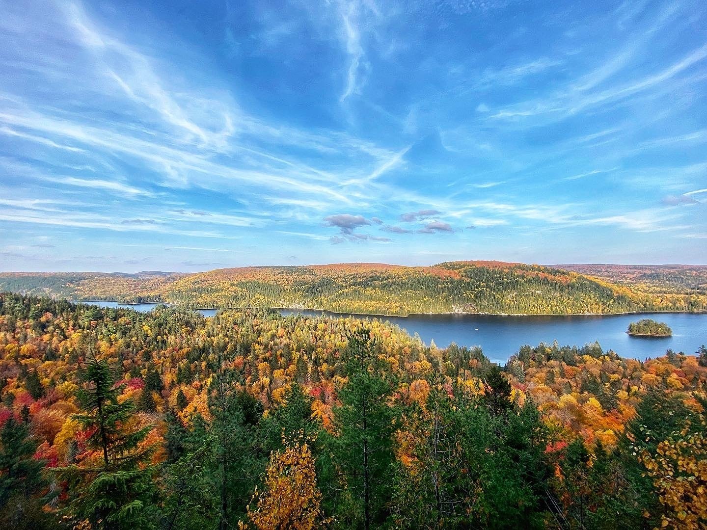
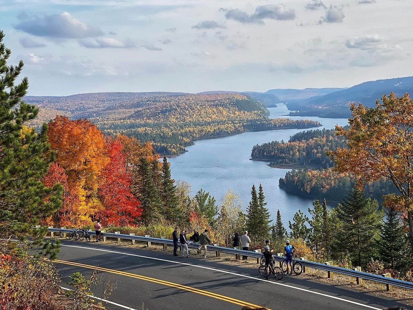
The Île-aux-Pins Lookout at La Mauricie National Park.
In the Laurentian mountains, in the Mauricie region of Quebec, is where you’ll find La Mauricie National Park.
I can’t remember the last time I went to place where I had so many moments where I was nearly speechless with the view before me.
Particularly as it relates to the park’s collection of strategic lookouts (more on that later), I’m quite sure that I simply walked around with widened eyes and barely able to speak (something anybody who knows me will understand is a feat unto itself).
In many respects, La Mauricie National Park is an outdoor adventurer’s playground. Camping, canoeing, kayaking and hiking opportunities abound.
I was fortunate to be shown around by Karine from Lanaudière Mauricie, a region described as “Authentic Quebec,” and I’m grateful that she showed me what makes this place special, so that I can share that information with you, dear reader, and help you explore a place that’s so worth exploring.
A Brief History of La Mauricie National Park
The formation of La Mauricie National Park is unique as far as national parks in Canada go. In 1970, Claire Kirkland-Casgrain and the honourable Jean Chrétien signed an agreement that noted this area would be nationally protected.
Then they got to work designing it. That’s part of what is unique about La Mauricie, first it existed largely in imagination and on paper, and then it slowly became a reality.
By 1975, almost 13 kilometres of road had been laid down, and trails, campgrounds and picnic areas were designed and implemented. In June of 1977, Canada’s 22nd national park was born.
I get the sense that this national park has always tried to march to the beat of its own drum. In 1979, for example, they were the first national park to ever host a sports competition when they held the Saint-Jean-des-Piles marathon.
In the 80s, the most notable achievement was “the Parkway,” which was paved across all 63 kilometres of the park. This crossed the park from one side to the other, which ultimately set the scene for it to be a park that was (and still is) beloved by cyclists, motorcyclists, and road trippers in general. The access to the park via road really is exceptional, and something I hadn’t seen before to this extent. One minute you’re on the road, the next you’re at a lookout that has your jaw dropping to the ground.
The government of Canada has continued to invest in this park over the years. They’ve restored many of the iconic facilities at La Mauricie National Park, but they’ve also added new lodges, visitor centres, tents, trails and the list goes on and on.
My fellow cyclists (I’ve written plenty about cycling in Ontario) will appreciate that the first cycling event to take place entirely in a Canadian national park also happened here back in 2007.
Over the years, the park has become increasingly popular and has become better known to those outside of the province of Quebec. For example, during Canada’s 150th anniversary celebrations, nearly 350,000 visitors were recorded. The numbers remain strong to this day, and below I’ll share why you’d be wise to try to make trip yourself!
How Best to Explore La Mauricie National Park
There are many different ways to explore this national park, and a lot of that will depend on preference. If you’ve got a motorcycle, for example, it’s probably the well maintained roads that’ll really get your heart beating with excitement, but if you’re a cross-country skier, then you likely can’t wait for first snowfall and for the national parks’ snow groomers to get to work.
I’ll list off how I best enjoyed the park when I visited, and help you figure out how you can do the same.
Get Out on the Water in a Canoe

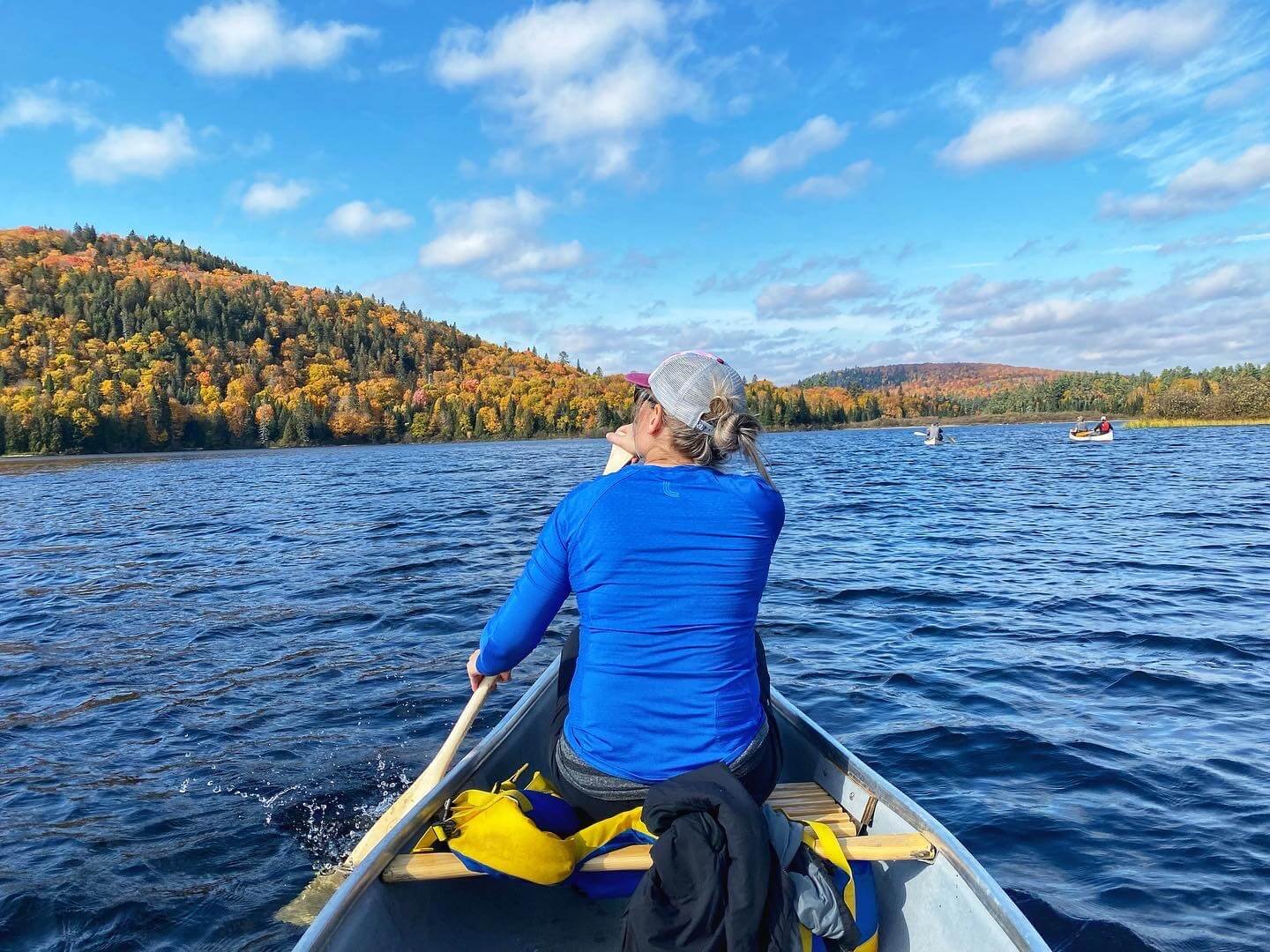
We arrived at Wapizagonke Lake, and shortly thereafter we had rented a canoe and were ready to go explore the park. There are three different location centres for rentals across the park that offer rentals for canoes, single kayaks, two-person kayaks, SUPs (stand-up paddleboards), and pedal boats. You can book ahead of time, as well as figuring out hours of operation here. We booked our canoe in advance because we knew it may be busy.
We got our canoe, and then put it into the water near the Wapizagonke picnic area. Our goal was to paddle about 4.5 kilometres to the start of the hiking trail that led to Waber Falls. It took us about an hour each way, so in sum, it was about 9 kilometres of distance, and two hours of canoeing. I didn’t think it was bad at all, really. There is a section where the lake narrows, and if the water is low you may need to get out and push, and you may also encounter a beaver dam or two, but it’s nothing that someone who has canoed before should be too worried about.
To give you a better picture of what this route would look like, I’ll include this map below.

You can see our route here. From Wapizagonke to Chutes Waber (Waber Falls). Credit: Parks Canada
Of course, this is far from the only route you can do. There are over 150 lakes at La Mauricie, and about thirty of those lakes are accessible both off the Parkway and on the network of canoe trails.
You can see a full map here to look at how you may want to plan your own canoe route by observing where the portages are, as well as the campsites and hiking trails. That being said, I would very much recommend the route that we did. It’s a full-day adventure (I’ll get into the hiking aspect of it below), but you’ll get a good taste for beauty of the park in about 6-8 hours (when you add up the canoeing, hiking, breaks, stopping for lunch, swimming at Waber Falls etc.).
There are no shortage of lakes to canoe on here, but just ensure you’re practicing safe boating.
Use of gas motors or electric motors aren’t allowed, so you won’t have to worry about dealing with the wake of speedboats and all that. If you do see a watercraft with a motor, it’s likely just staff getting around the park, but the motor won’t have a lot of horsepower.
Break Out the Boots and Go Hiking

A viewpoint on the way to Waber Falls from Lake Wapizagonke.
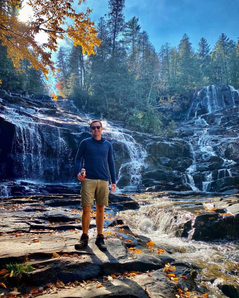
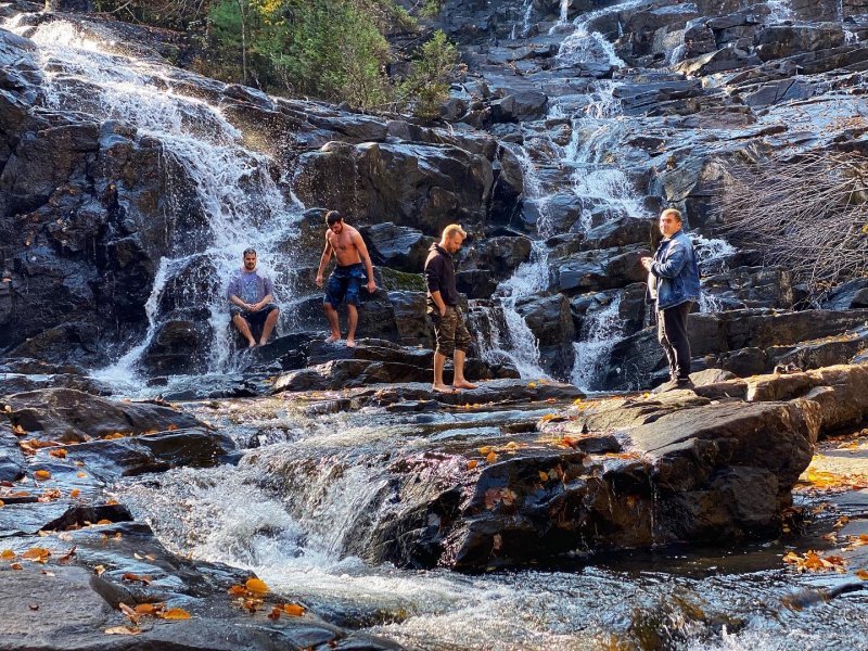
There are some fantastic hiking trails at La Mauricie. It’s a hiker’s paradise in many respects, or at least that’s the way I felt after we did the Chutes Waber / Waber Falls Hike. From the docking point at the end of Lake Wapizagonke (where you can leave your canoe, no problem) to Waber Falls was about 7 kilometres there and back. In all, it took about 1 hour and 45 minutes, and it had a 197 metre elevation gain.
We brought lunch with us (and even a beer), and stopped for about an hour right at the bottom of Waber Falls. Many others had the same idea, and I think we were all happy that we ended up there. I get the sense that the Waber Falls hike is the most famous just because of how famous Waber Falls itself is, but there are many other hikes to consider.
You can see maps here if you’re more visual, but I’ll quickly go over some prominent routes below. In depth descriptions of each route can be found here.
Les Cascades - 2 kilometres (easy)
Les Falaises - 3.8 kilometres (intermediate)
Rousseau-Brodeur - 1.4 kilometres (easy)
La Tourbière - 300 metres (easy)
La Terrasse - 3.8 kilometres (easy)
Lac-Gabet - 3 kilometres (easy)
Chute Parker - 8.2 kilometres (intermediate)
La Cache - 3 kilometres (easy)
Lac-Êtienne - 1.4 kilometres (easy)
Deux-Criques - 17 kilometres (difficult)
Mekinac - 11 kilometres (intermediate)
La-Solitaire - 5.5 kilometres (difficult)
Ruisseau-Bouchard - 8.3 kilometres (difficult)
Lac-du-Pimbina - 13.1 kilometres (difficult)
Lac Rei - 7.9 kilometres (intermediate)
Plan to Picnic at Waber Falls
I know I mentioned this in the above section, but in case anybody is in a rush and skimming the article quickly, I need to make sure this isn’t missed, so it’s getting a quick section!
We planned our canoe and hiking routes in order to be able to have a picnic at Waber Falls, and having lunch there was more than worth the effort to get there and back.
I won’t soon forget eating great local cheese, sipping on local beer (we packed well), and letting the sounds of the waterfall iron out any stress I might have carried with me there. I’m grateful Karine was along for the ride as she was able to tell me that the water is usually rushing much faster and stronger than when I was there with her. However, that allowed me to get right up to the falls and to capture one of my favourite moments in recent memory, which is pictured just above.
Find the Red Chairs at La Mauricie National Park
Recently, Park Canada placed over 200 red Adirondack chairs in some of the most scenic places across the country. There are 7 red chairs in La Mauricie National Park. Some of the chairs are easy to find, while others are a fair bit harder. You can find the exact coordinates here, but I’ll let you know where they are approximately below.
Lax aux Chevaux (on the Lac-Solitaire Trail no. 13)
Rosoy (take the Mekinac Trail)
Vide-Bouteille Beach (two chairs only accessible if you row halfway between Shewenegan and Wapizagonke picnic areas)
Mystery (there’s one big red chair that’s moved around the park regularly)
Drive to the Most Notable Vantage Points in the Park
Le Passage Lookout at La Mauricie National Park.
The following are scenic viewpoints that you can drive to on the Parkway. There are signs in the park, and they’re noted on different maps, but you can also find them on Google maps itself, which makes them nice and easy to get to.
Le Passage Lookout: This view of a curving and snaking Lake Wapizagonke is like something from a postcard. You can pull over to the side of the road (though it’s discouraged from what I understand), or you can enter from up above and get some extra elevation. Do yourself a favour and do not miss this view.
Île-aux-Pins Lookout: The reason to come to this lookout is that you’ve got a view of a tiny tree topped island that looks like it was placed there by an artist for dramatic effect. This view also gives you a better idea of just how long and narrow Lake Wapizagonke is. Again, don’t miss this.
Vide-Bouteille Lookout: This viewpoint offers a sweeping view of the forest and lake, and I think does a nice job of showcasing how high up you are. The Vide-Bouteille Lookout gives a good sense of scale - it’s humbling in a positive way.
There are other lookouts in the park, but these are the ones you can access by car. The other “photo spots” that you can get to either by hiking or canoeing (or both) include Anticagamac Lookout, Bouchard Creek, Lac Benoît Lookout, Chute Parker, Mekinac Floating Bridge, and Pique-nique Shewenegan.
Consider the Season
I mention this because La Mauricie National Park is very much a four season park. Obviously, I was able to go in the fall, and I was awfully happy about that because of the surreal autumn foliage that might just be the best I’ve ever seen.
In the warmer months, you can focus on paddling, cycling, bird watching, camping, canoeing, hiking, mountain biking, kayaking, fishing, stargazing, and hanging out on the beaches.
In the colder months, you can focus on cross country skiing, winter camping (there’s winter accommodation available), stargazing, snowshoeing, ice climbing and winter walks and hikes. Note that you can rent trekking poles, crampons, snowshoes and baby carrier backpacks straight from the park.
They think of the park is being two different seasons with the winter season extending from December 13th - March 31st.
What Else is Worth Knowing?
If you’re planning a trip to Quebec and want to add La Mauricie National Park to your itinerary, it’s worth noting that La Mauricie National Park is located roughly halfway between Montreal and Quebec City.
Most people arrive from the Saint-Jean-des-Piles Entrance (leave highway 55 at exit 226) or the Saint-Mathieu Entrance (leave highway 55 at exit 217). There are 28 electric vehicle charging stations for any drivers of electric cars.
Finally, some fees apply, and put simply, if you’re a lover of the outdoors the seasonal admission will likely be your best bet. Plus, worst case scenario, you’re just helping to support Parks Canada, which is always a good thing. You can learn about that here.
Is La Mauricie National Park Canada’s Most Underrated National Park?
I’ve seen this question appear over and over again as I’ve done some further research to make sure I’ve got you all set for your visit. The short answer is that I don’t know just yet, since I haven’t visit every national park in the country.
What I can say, however, is that I was utterly blown away.
I reflect back on my visit to La Mauricie and I can’t recall ever seeing a view that wasn’t the best of what nature has to offer. The addition of the vantage points, and that La Mauricie was created with the visitor in mind, brings it all to a whole other level.
If you leave near La Mauricie National Park, I’d recommend you make the trip. If you leave far away from La Mauricie National Park, I’d recommend you make the trip.
I’ve only just been, and I’m already yearning to go back. Perhaps I’ll see you there.
I want to humbly thank Lanaudière Mauricie for hosting me as media. All opinions are completely my own.
If you appreciated this article, you’ll love our newsletter, as well as our Facebook group! Feel free to join, all are welcome. If you’ve got any questions or comments, add them below, and I’ll be sure to get back to you.